The Sea Knocks Three Times: Cyclone Akvan and the Warning Andhra Pradesh Cannot Afford to Ignore

Three times in a single month, the sea has knocked on the same door. Will we answer it, or will we wait, as we have waited before, for it to break the door down?
On Monday, 16 November 2026, a deep depression over the Bay of Bengal gathered itself into Cyclone Akvan. The India Meteorological Department says it will cross the Andhra Pradesh and Yanam coasts between Nellore and Tuni around noon on Friday, 20 November, as a very severe cyclonic storm, with sustained winds of 120 to 130 kilometres an hour, gusting to 145. Heavy rain will begin on Wednesday. Extremely heavy rain, twenty-one centimetres or more in places, is expected on Thursday and Friday. A surge of one to two metres above the tide is forecast to flood low-lying land in Prakasam, Bapatla, Krishna, West Godavari, Konaseema and Kakinada districts.
Read those dates again. Akvan is expected to strike on 20 November. Forty-nine years ago, on 19 November 1977, a cyclone of almost the same strength came ashore on almost the same coast and drowned the island of Diviseema under a seven-metre wall of sea. Ten thousand people died, officially. Some say fifty thousand. The sea does not deal in anniversaries, and yet the calendar itself seems to be keeping a record we refuse to keep.
This is not a weather report. Weather reports tell you when to carry an umbrella. This is a letter, the third in a month, from a sea that has run out of patience. And like all letters that arrive three times, it deserves to be read properly, from the beginning, with history standing beside us as a witness.
The storm that is coming
Let us be precise, because precision is a form of respect for the people in the path of this storm. At half past five on Monday evening, Cyclone Akvan lay centred about 610 kilometres east of Chennai, 670 kilometres south-southeast of Visakhapatnam and 660 kilometres southeast of Machilipatnam, moving west-northwest at ten kilometres an hour. The IMD expects it to become a severe cyclonic storm by the evening of Tuesday, 17 November, and a very severe cyclonic storm by the night of Thursday, 19 November, before crossing the coast at noon on Friday.
The name Akvan comes from the regional naming list maintained by the World Meteorological Organisation’s panel on tropical cyclones; it was contributed by Iran. Names are a courtesy of the forecasters, a way of making the impersonal personal. But do not be misled by the gentle sound of it. A very severe cyclonic storm is not a monsoon shower. At 145 kilometres an hour, the wind tears roofs from houses, snaps concrete electricity poles like twigs, and turns every loose sheet of tin into a blade. The rain that falls in its wake does not merely wet the earth; it drowns fields, breaches bunds, and turns roads into rivers. And the storm surge, that quiet phrase in the bulletins, is the sea itself walking inland, one to two metres high, into villages that have stood on that shore for generations.
Four states are under warning: Andhra Pradesh, Tamil Nadu, Odisha and West Bengal. Fishermen have been told not to venture into the sea. Offshore operations have been halted. The Andhra Pradesh State Disaster Management Authority has placed the coast on an orange alert, the second of the IMD’s four warning stages. These are the correct measures, and they will save lives. But I ask you, the reader, to hold one question in your mind as you read the rest of this column: why is this the third time in a month that these measures have been necessary?
A coast that has not yet buried its dead
Akvan is not arriving on a healed coast. It is arriving on a coast still counting its losses from two storms that came before it, so recently that the mud on the roads has barely dried.
Cyclone Arnab made landfall near Narsapur on 28 October, a very severe cyclonic storm with winds of 125 to 135 kilometres an hour, gusting to 150. Cyclone Murasu followed on 2 and 3 November, crossing the coast near Ongole. Between them, the two storms damaged agricultural crops across 4,61,194 hectares and horticultural crops across nearly 30,000 hectares more. Arnab alone struck 3,27,843 hectares in fifteen districts and affected 5,23,136 farmers; its crop losses are estimated at 9,78,091 tonnes, worth Rs 2,392.84 crore. Murasu damaged another 1,33,351 hectares across nine districts, affecting 1,86,269 farmers, with losses of Rs 816.53 crore. Together, the preliminary damage from the two cyclones exceeds Rs 7,000 crore. Twelve people died. Thirty thousand electricity poles were damaged by Arnab; Murasu damaged another ten thousand. In Odisha, more than 1.18 lakh people were affected, over 75,000 hectares of farmland destroyed, and 1,672 houses damaged in Ganjam and Kandhamal districts alone.
Read those numbers slowly, because numbers are the only honest language a disaster speaks. In one district, Konaseema, Arnab damaged 99.19 per cent of the cultivated area. Ninety-nine per cent. Imagine a farmer who has tilled the same soil his father tilled, who watched a single night’s wind erase a season’s work, and who then, a week later, watched it happen again. The state government has sought Rs 815.57 crore from the State Disaster Response Fund and Rs 714.96 crore from the National Disaster Response Fund for Arnab alone, and hundreds of crores more for Murasu. These are requirements, not payments received. The money, like the rain, is promised before it arrives.
And now, before the assessment of the second storm is even complete, before the horticultural damage from Murasu has been fully counted, a third storm is four days away. This is what the officials call a “cluster”. The farmers of coastal Andhra Pradesh have a shorter word for it, and it is not printable in a family newspaper.
The ghosts of Diviseema and Paradip
History is not a museum in this country. It is a mirror, and the mirror is standing in the middle of the road.
On 19 November 1977, a cyclone with winds of 230 kilometres an hour struck the Krishna delta. The island of Diviseema was hit by a storm surge seven metres high. About a hundred villages were marooned or washed away. The official count was 10,841 killed or missing, and 34 lakh people were rendered homeless. The Janata Party government of the day believed the true toll was at least 50,000. A memorial stands today at Avanigadda, at the furthest point the tidal wave reached, in memory of the people who died. Go and stand before it, if you ever doubt that the sea keeps accounts.
Twenty-two years later, on 29 October 1999, the super cyclone struck Odisha near Paradip with winds above 260 kilometres an hour and a storm surge six to seven metres high that pushed seawater twenty kilometres inland. The official death toll was 9,887; some estimates run far higher. Nearly 7,000 of those deaths were caused by the surge alone. Jagatsinghpur district, which bore the brunt of the landfall, recorded more than 8,000 deaths. In all, 12.9 million people were affected. Only 150,000 people had been evacuated. There were just twenty-three permanent cyclone shelters in the whole of coastal Odisha.
I set these two dates before you, 1977 and 1999, because they are the two great teachers of this coast, and because their lessons point in opposite directions. The lesson of 1977 was that a coast without warning is a coast without defence. The lesson of 1999 was that a coast without shelters is a coast without mercy. And the lesson of both, taken together, is that the sea does not forgive a people who forget.
But there is a third date, and it is the one that should give us hope. On 12 October 2013, Cyclone Phailin struck Odisha with an intensity comparable to the 1999 super cyclone. This time, nearly one million people, 1,154,725 by the official count, had been evacuated ahead of landfall. The death toll was 44. Forty-four, against nearly ten thousand. That is not luck. That is what happens when a nation learns. The Odisha State Disaster Management Authority, created in the ashes of 1999, and the National Disaster Management Authority, established in 2005, turned a graveyard into a model that the whole world now studies. When Cyclone Fani came in 2019, 1.2 million people were moved to safety in twenty-four hours.
So the question before us is not whether we know how to survive these storms. We do. We proved it in 2013. The question is whether we will do, every single time, what we know how to do, and whether we will do it for the farmer as faithfully as we do it for the city.
The sea is warmer, and the storms are quicker to anger
Now I must say something that the honest columnist cannot avoid, even though it will displease those who prefer their weather without politics. The sea is warmer than it was, and warm seas make angry storms.
Global sea surface temperatures in September 2026 stood 1.10 degrees Celsius above average, a record for the fourth consecutive month. A supersized El Niño is gathering in the Pacific; between July and September 2026, sea surface temperatures in the Niño 3.4 region ran 2 to 2.8 degrees above normal. The former director general of the IMD, K. J. Ramesh, has said plainly that warmer-than-normal sea surface temperatures and the influence of El Niño may have contributed to the intensity of this season’s storms. A cyclone runs on heat and moisture from warm water, as an engine runs on fuel. Give the engine more fuel, and it runs faster and hits harder.
But honesty cuts both ways, and I will not insult your intelligence by claiming more than the science allows. The number of cyclones in the Bay of Bengal has not risen significantly, even as the ocean has warmed; a study in the journal Nature says so plainly. Two cyclones in one week, or three in one month, cannot by themselves be called proof of climate change. One season is weather, not a trend. What the same science does say, and says with growing confidence, is that the storms that do form are strengthening faster. Under a high-emission scenario, rapid intensification, a storm gaining strength very quickly within a day or so, is projected to become about 39 per cent more common in the Bay of Bengal by the end of this century.
There is a cruel piece of physics behind this. After the monsoon, rain and the great rivers leave a layer of fresh water floating on the surface of the Bay. Fresh water is lighter than salt water, so it floats, and a storm’s winds struggle to stir up the cooler water below, the usual brake on a storm. A 2012 study found that storms cool the Bay’s surface about three times more before the monsoon than after it, and that about 40 per cent of that difference comes from this fresh layer. Across the world’s oceans, storms strengthen nearly 50 per cent faster over such layers. The Bay of Bengal, in other words, is built to make strong storms, and we are now handing it warmer water to work with.
Look across the water to the Arabian Sea, and the warning grows louder. Scientists at the Indian Institute of Tropical Meteorology in Pune compared the two decades from 2001 to 2019 with the two before them, and found that in the Arabian Sea, cyclonic storms became about 52 per cent more frequent, very severe cyclones about 150 per cent more frequent, storm lifetimes grew by about 80 per cent, and the total accumulated cyclone energy roughly tripled. The Arabian Sea was once the quieter sea. It is quiet no longer. The Bay has been spared that particular trend so far, but the sea does not respect our categories. It respects only physics.
While Antalya argues about a number
As Akvan gathers itself in the Bay, another gathering is under way in Antalya, in Türkiye, where the COP31 climate summit has reached its midway point. The delegates there are arguing over a number: 1.5 degrees Celsius. For a decade, that number was the north star of climate action, the line nations pledged to hold. Now the United Nations has said plainly that the line will be crossed. The UN Environment Programme’s Emissions Gap Report 2026, titled “The Point of Return”, finds that under current policies the world is heading for about 2.8 degrees of warming this century, and even if every national climate plan is fully delivered, about 2.6 degrees. The lowest-overshoot path now requires emissions to fall, relative to 2025 levels, by 18 per cent by 2030, 45 per cent by 2035, and 69 per cent by 2040.
Some nations at Antalya want the final deal to affirm that 1.5 degrees remains the right goal. Others, including the Arab Group and the Like-Minded Developing Countries, are quietly manoeuvring to jettison it. The Secretary-General, António Guterres, who has spent a decade rallying the world behind that number, told the summit that any overshoot must be “as small as possible, for as short a time as possible”. “Overshoot is not surrender,” he said.
He is right, and yet I ask you to consider the distance between that conference hall and the coast of Andhra Pradesh. In Antalya, 1.5 degrees is a negotiating position. In Konaseema, it is the temperature of the water that drowned a season’s paddy. The World Meteorological Organization reports that the average global temperature between January and September 2026 was approximately 1.47 degrees above the pre-industrial average, and that 2026 will be among the four warmest years ever recorded. The sea does not attend conferences. It does not wait for consensus text. It simply warms, and rises, and returns to the shore to collect what it is owed.
I do not write this to mock the negotiators. I write it to remind them, and you, that every fraction of a degree they argue over is measured, in the end, not in communiqués but in hectares of drowned paddy, in snapped electricity poles, in the number of farmers who must begin again with nothing. The farmer in Krishna district does not need a new target. He needs a roof that holds, a warning that reaches him in time, and a government that pays what it promised before the next storm arrives.
What must happen before Friday noon
There are four days between this column and landfall. Four days is a long time in a disaster, if it is used well, and no time at all if it is wasted. So let me say plainly what must happen, and let the record show that it was said in time.
First, evacuation must begin now, not on Thursday night. The lesson of Phailin is that a million people can be moved when the order is given early and the shelters are ready. The districts in the surge zone, Prakasam, Bapatla, Krishna, West Godavari, Konaseema and Kakinada, must move their people from the low-lying villages to the cyclone shelters before the rain begins, because once the rain begins, the roads themselves become the danger. The fishermen who are still at sea must be brought in, and the boats secured. The elderly, the sick and the children must be moved first, as a matter of honour, not of convenience.
Second, the shelters must be stocked and staffed. A shelter without food, water, medicine and light is a warehouse with people in it. The failures of 1999 were not only failures of warning; they were failures of preparation. Odisha learned that lesson at the cost of ten thousand lives. Andhra Pradesh must not pay the same price twice.
Third, the power and communication networks must be protected and restored with the speed we saw after Arnab, when 30,000 damaged poles were put back up, and the lesson must be carried further: a warning that cannot reach a village is not a warning. Every village in the landfall zone must hear the siren, the loudspeaker, the knock on the door.
Fourth, and this is the one that history will judge, the relief must be honest and it must be fast. The assessments for Arnab and Murasu are still incomplete; thousands of farmers are still waiting for enumeration, and the money sought from the disaster response funds is still, in the main, a request rather than a payment. A farmer who lost his crop to Arnab, lost it again to Murasu, and now faces Akvan, cannot eat a promise. The state sought central assistance after the first two storms. The Centre must answer before the third, not after it.
And there is a fifth duty, which belongs to all of us who watch from a safe distance. Do not turn this storm into a spectacle. Do not share the frightening video and move on. The people of coastal Andhra Pradesh are not characters in a disaster film. They are farmers and fishermen and mothers and schoolchildren, and they have now been visited by the sea three times in a month. They deserve our attention for longer than a news cycle.
The sea keeps the accounts we refuse to keep
I began with a question, and I will end with a verdict. The sea has knocked three times on the same coast in a single month. The first knock cost Rs 4,600 crore. The second cost Rs 2,484 crore. The third is still at sea, gathering strength, four days from the shore.
History has given this coast two great teachers. Diviseema taught us what happens when there is no warning. Paradip taught us what happens when there is no shelter. Phailin taught us what happens when a nation remembers both lessons at once: forty-four lives, against ten thousand. That is the whole of the argument, contained in two numbers.
But history also teaches a harder lesson, the one we prefer not to learn. A warning ignored is not a warning postponed; it is a debt, and the sea collects its debts with interest. Every fraction of a degree we argue over in Antalya, every rupee of relief delayed in a file, every shelter left unstocked, is added to the account. The Bay of Bengal does not send invoices. It sends storms.
So I say to the officials in Amaravati and in New Delhi, and to the negotiators in Antalya, and to you, the reader who has come this far with me: the sea has spoken three times. It will not speak a fourth time in a whisper. Move the people. Stock the shelters. Pay the farmers. And when the storm has passed, do not call it an act of God and walk away. God gave us the science to foresee it, the shelters to survive it, and the memory of 1977 and 1999 to warn us. What remains is for us to use them, before the sea, in its patient and terrible way, teaches the lesson again.
Sources & References
Watchers News — Cyclone Akvan landfall forecast: IMD outlook, track and intensity, 16 November 2026.
Transclew — Cyclone Akvan live updates: IMD Bulletin No. 10, storm surge and rainfall forecasts, 16 November 2026.
The Daily Jagran — Cyclone Akvan to make landfall in Andhra Pradesh on 20 November; IMD forecast and alerts, 16 November 2026.
Telugu360 — Third cyclone in three weeks: damage estimates of Rs 7,000 crore from Arnab and Murasu, 16 November 2026.
Hi India (IANS) — Arnab and Murasu damaged crops over 4.61 lakh hectares in Andhra Pradesh; official figures reviewed 10 November 2026.
The Hindu BusinessLine — 23 years on, Odisha super cyclone horrors still haunt survivors; official toll 9,843, Phailin evacuation, 30 October 2022.
Wikipedia — 1977 Andhra Pradesh cyclone: Diviseema, seven-metre storm surge, official toll of 10,000, 19 November 1977.
The News (AFP) — Nations grapple with loss of 1.5C target at UN climate summit, COP31 Antalya, November 2026.
Daily Drolls — COP31 Antalya: UN Emissions Gap Report 2026, overshoot pathways and projections, November 2026.
The Hindu (via LearnThruPractice) — Many twists in the monsoon’s tale: Arnab and Murasu, rapid intensification and the Nature study, 8 November 2026.
Transclew — Why the Bay of Bengal gets more cyclones than the Arabian Sea; IMD records 1891–2025 and the fresh-water layer research.
MrVitej — From low pressure to super cyclone: India’s cyclones explained, 2014 to 2026; Deshpande et al. 2021 Climate Dynamics findings.
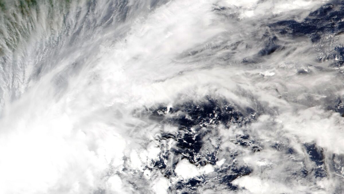
Wikimedia Commons — Featured image: Depression BOB 10 over the south-central Bay of Bengal, 15 November 2026; VIIRS imagery from NOAA’s NOAA-20 satellite, public domain.
Featured image: Depression BOB 10, the system that became Cyclone Akvan, over the south-central Bay of Bengal on 15 November 2026. VIIRS imagery from NOAA’s NOAA-20 satellite, via Wikimedia Commons (public domain).

About the Author — Abdul Mannan
Related Articles
They Caught a Spaceship Out of the Sky — and the World Cannot Decide Whether to Cheer or Weep
On Saturday 14 November 2026, SpaceX caught a spacecraft that had been to orbit — Ship 42, fresh…
Bahrain at 4 A.M.: The Small Island Caught Between Two Empires — and the Strait the World Cannot Afford to Lose
At 4 a.m. on Sunday, sirens sounded over Manama as Iran claimed a second drone attack on a…

The Car You Buy But Never Own: Tesla’s $29,990 Cybercab and the $299-a-Month Future
Tesla's $29,990 Cybercab has no steering wheel, no pedals — and no motion without a $299-a-month subscription. A…